Welcome to the Mega North Korea Map! This post will be a series of maps of major North Korean locations of interest. We’ll also go over as to how North Korean maps have changed in recent history. Just to make things clear, the official name of North Korea is the Democratic People’s Republic of Korea which is abbreviated as DPRK. This is not to be confused with the official name of South Korea which is the Republic of Korea, or ROK.
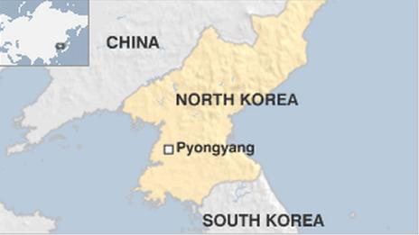
Table of Contents
Maps of North Korean Cities
Pyongyang (평양)
First, let’s start off with the capital of the DPRK- Pyongyang. This map above shows the main features that one would see upon visiting Pyongyang with Young Pioneer Tours. The city is split by the Taedong River, known as 태동강 Taedonggang in Korean. On this map, you can see attractions such as Juche Tower, Kim Il-Sung Square, the Party Foundation Monument, and Ryugyong hotel. Google has produced very detailed and accurate maps of Pyongyang. Want to feel like a secret agent and snoop around, learning about every corner of Pyongyang? Check out this link here. You can find more info by checking out Pyongyang Map on google maps.

Looking to use the metro in Pyongyang? No problem! You can memorize your stops before you enter North Korea for your trip! Definitely one of our favourite North Korean maps!
To read more about the Pyongyang Metro click here.
Maps of Rason (라선) Special Economic Zone
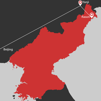
There aren’t many maps of the city of Rason Special Economic Zone, but the map above shows its location in the far northeast corner of the DPRK. This is one of the least visited parts of the DPRK that is actually more open to tourists. You can freely walk around the markets and use North Korean Won to purchase items for yourself. Check out more with our independent tours there. Did you also know, that if the DPRK’s economy opens up to the world that Rason has the potential to become North Korea’s Shanghai or Shenzhen? Read about it here.
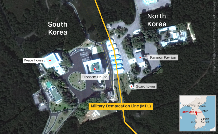
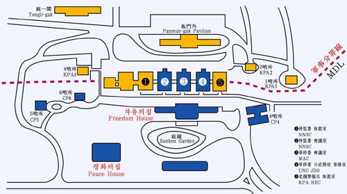
Maps of the Demilitarized Zone (DMZ) at Panmunjeom (판문점)
The Demilitarized Zone or DMZ is a 4 km wide buffer zone that stretches across the Korean Peninsula. It divides North and South Korea. The Military Demarcation Line is where the 2 km on each side is measured from. The famous Joint Security Area is also located on a portion of the MDL. It’s the famous border with blue buildings where negotiations take place. Read more details here. Young Pioneer Tours offers DMZ Day tour extensions.
How the North Korea Map Changed Overtime
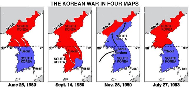
Map of North Korea in 1950
After Japan was defeated in WWII, the Korean peninsula was split between Soviet influence in the North, and US influence in the south. The border was split evenly on the 38th parallel line of longitude. Long story short, neither side was going to realistically agree with a unifying government. After that, North Korean troops almost overwhelmed the south until UN peacekeeping forces led by the United States drove them back north.
Map of the North Korean Border in 1953
This almost succeeded until Communist China decided they weren’t having it and sent troops across the Yalu River in support of the North Korean troops. The idea of a US-friendly state on their border wasn’t going to happen. As a result, fighting ensued until it resulted in today’s border, with the Korean Armistice Agreement in 1953. Keep in mind, the Korean Armistice Agreement only ended fighting; it did not officially end the war in 1953.
In conclusion, North Korean geography still has much to be discovered. We hope you can discover with us on a Young Pioneer Tours excursion!