Alongside a series of territorial disputes with Russia and Russian backed separatists, with a population of 40 million people living in an area of 10.18 million km², Ukraine is a beast of a country to map. But fear not, YPT has managed to cover everything you need to know when it comes to mapping the fascinating country of Ukraine. In this section, we look at everything from the general overview and specific regions to border crossings and the places in Ukraine you really shouldn’t go!
Map of Ukraine
Ukraine is bordered by Belarus to the north, Russia to the east, the Sea of Azov and the Black Sea to the south, Moldova and Romania to the southwest, and Hungary, Slovakia, and Poland to the west. In the far southeast, Ukraine is separated from Russia by the Kerch Strait, which connects the Sea of Azov to the Black Sea.
Most of the territory of the vast country of Ukraine lies within the Great European Plain, while parts of western regions and southern regions lay within the Alpine system. In general, Ukraine comprises two different biomes: mixed forest towards the middle of the continent and steppe towards the Black Sea. The western regions feature alpine-like sections of the Carpathian Mountains but Mountains are largely limited to the west of Ukraine. Most of Ukraine’s area is taken up by the steppe-like region just north of the Black Sea which consists of fertile plains and plateaus.
Map of the Rivers of Ukraine
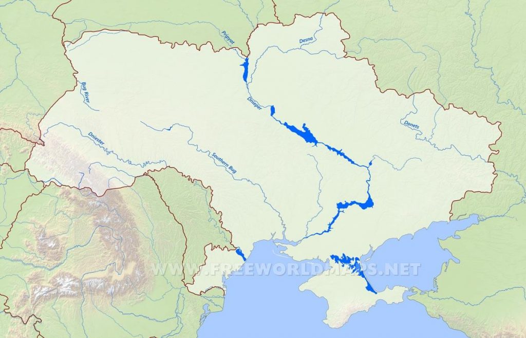
The Dnieper River, with its hydroelectric dams, huge reservoirs, and many tributaries, dominates the entire central part of Ukraine. Of the total course of the Dnieper, 609 miles of it are in Ukraine, making it by far the longest river in Ukraine. Like the Dnieper, the Southern Buh flows into the Black Sea. To the west and southwest, the Dniester also flows into the Black Sea. The Donets River flows through southeastern Ukraine and is an important source of water for the Donets Basin in Donbass. The Danube River also flows along the southwestern frontier of Ukraine. Marshland covers around 3 percent of Ukraine and is found mainly in the northern river valleys and in the lower reaches of the Dnieper and Danube.
Map of Kyiv
The Ukrainian Capital of Kyiv is located on the Dnieper River. The center of the city is 330 feet above the river level. The wooded bank where the center is located, topped by the golden domes and spires of churches and bell towers and by high-rise apartment buildings, makes Kyiv an impressive sight from across the Dnieper. Since World War II, Kyiv has extended onto the wide, low, and flat floodplain on the left bank of the Dnieper river.
The city limits of Kyiv enclose an area of 300 square miles on both banks of the Dnieper. It is divided into a number of administrative wards. The focus of Kyiv is the area of the ancient Upper Town, sitting on the hills above the Dnieper. Although largely of postwar construction, this central area still has its old street pattern, and most of the surviving historical and architectural monuments are located there.
Map of Border Crossings
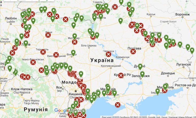
Ukraine has over 60 border crossings into the country whether by road, rail, sea, or air. However, some border crossings such as the ones leading into Crimea or separatist-controlled territory are closed for regular foreigners. Crossing into Ukraine via any of these border posts that are not under the control of the central authorities in Kyiv is highly unadvised.
In our experience, for independent travelers the best border crossing to enter and leave Ukraine is via an airport. Road crossings are a lot more chaotic than airports and can have issues that airports do not have. Corruption is known to take place and for those who do not speak Russian, it can be an intimidating experience. On our tours to the region, we sometimes enter or leave via road borders but your YPT is in charge of handling the border control.
Volatile regions of Ukraine
Following the Euromaidan revolution in 2014 and the subsequent chaos that followed, there are three regions of Ukraine that are currently in a state of territorial dispute and open warfare. Crimea, Lugansk, and Donetsk.
Crimea was annexed by Russia in 2014 and became absorbed into the Russian Federation. However, this is largely unrecognized by most of the world. Entry to Crimea through Russia is illegal under Ukrainian law and the border into Crimea from Ukraine is closed to foreigners.
The regions of Donetsk and Luhansk are largely under separatist control and in a state of open warfare between separatist forces and the Ukrainian military. Travel to the Eastern regions in Donbass is not advised due to the risk of being caught in open warfare, being arrested, or killed.